 |
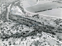
| What's missing in this photo? Photo by Francis "Fuzzy" Swayze, probably in the 1960s. Click on any image to enlarge. |
Looking at the photograph reminded me how memory can fool you, and, if possible, it’s best to rely on the written or photographic record. My memory of a place did not correspond to the evidence in the photograph.
The Lehmanns let me copy a batch of photographs of Louise Hays Park; most were taken on April 26, 1950, when the park was built in a single day. (The images the Lehmanns shared with me are different from the ones shown here last week, which were collected by the Hays family.)
Among the photos was one taken later, possibly in the 1960s, by Francis "Fuzzy" Swayze, my friend who recently turned 100. It's an aerial photo showing what is now Tranquility Island and most of the original part of Louise Hays Park, from upstream on the Guadalupe River, looking downstream.
When I first looked at the image I thought I recognized the river and the streets, but one landmark was missing: the Francisco Lemos Street Bridge.
 |
| Detail, 1934 Map of Kerrville |
Given the bridge’s existence in 1934, I assumed the crossing had been open since that time. I was wrong.
The 1960s photograph shows a concrete span over the Guadalupe, the ruins of which I remember seeing just downstream from the old low-water Francisco Lemos crossing. (Those ruins and the former low-water Lemos Street Bridge were replaced the current bridge in late 2009.)
What the 1960s photo does not show is a connection between the concrete span and the end of Francisco Lemos Street. At the end of the pavement a pair of dirt tracks head down toward the river bank, but these dissolve into what appears to be a game trail, and then, unexpectedly, just end, shy of the concrete span.
 |
| A different view, with labels. |
The bridge on Francisco Lemos Street, connecting to Thompson Drive, which I thought had been there when I was born, was simply not there. I learned from old newspapers the low-water bridge was not completed until 1971, a full decade after I arrived on the scene.
I have a feeling the photographs were taken to help plan for the expansion of Louise Hays Park, and to suggest improvements there. However, they may have been taken to help build the case for the state to construct the Francisco Lemos Street bridge, as Spur 98.
Regardless, they show a portion of town which has changed a lot in the last few decades, with the taming of Tranquility Island and the recent construction of the River Trail. The area, which was a nearly impassable wilderness, is now visited by hundreds of folks every day.
I’m grateful to the Lehmanns for their generosity in sharing these photographs with me, and I’m happy I get to share them with you here.
Until next week, all the best.
 |
| Click here for FREE shipping to any US address |
Did you know I have two books available, both filled with historic photographs of Kerr County? Both books are available at Wolfmueller's Books, Herring Printing Company, and online by clicking HERE.


No comments:
Post a Comment
Please remember this is a rated "family" blog. Anything worse than a "PG" rated comment will not be posted. Grandmas and their grandkids read this, so please, be considerate.